电脑桌面
添加小米粒文库到电脑桌面
安装后可以在桌面快捷访问

测绘学术语中英文对照VIP免费

测绘学术语中英文对照_第1页
1/46
测绘学术语中英文对照_第2页
2/46
测绘学术语中英文对照_第3页
3/46
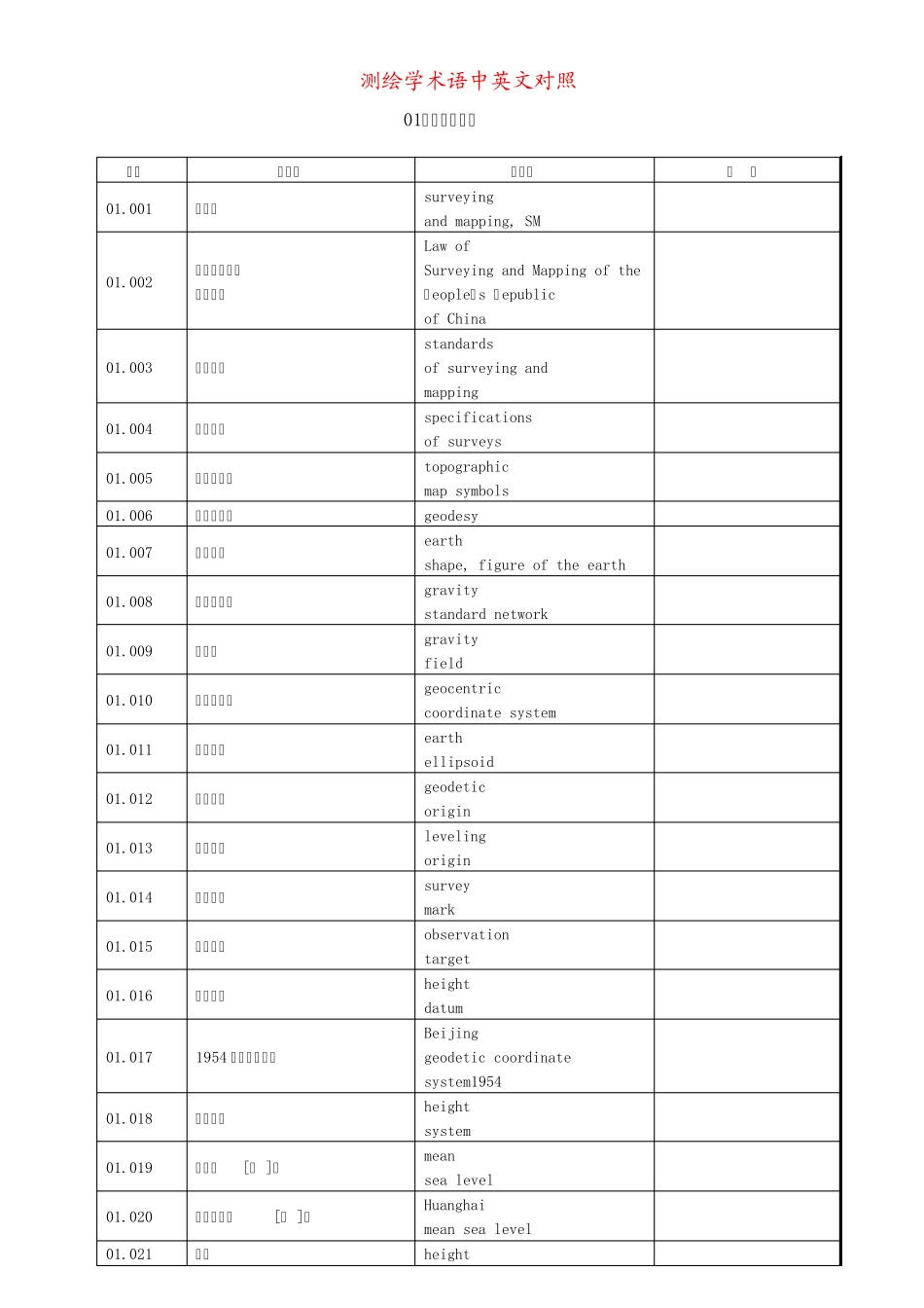
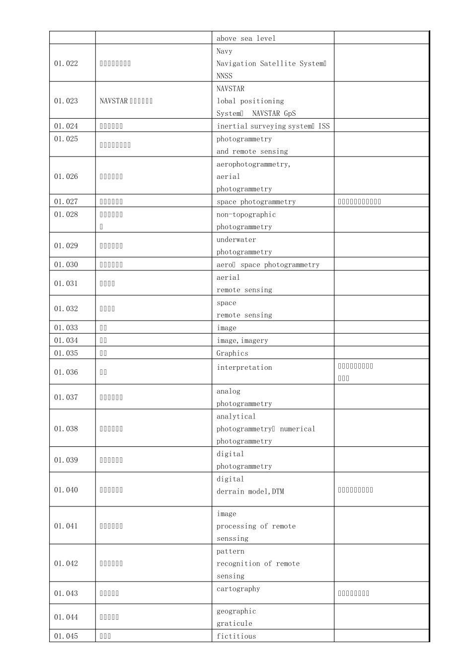
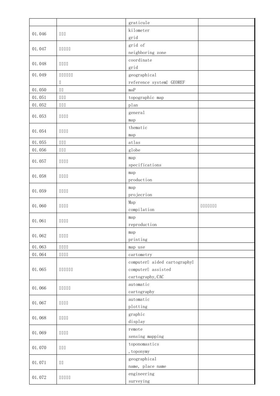
测绘学术语中英文对照 01.普通测量学 序码 汉文名 英文名 注 释 01.001 测绘学 surveying and mapping, SM 01.002 中华人民共和 国测绘法 Law of Surveying and Mapping of the Peopleˊs Republic of China 01.003 测绘标准 standards of surveying and mapping 01.004 测量规范 specifications of surveys 01.005 地形图图式 topographic map symbols 01.006 大地测量学 geodesy 01.007 地球形状 earth shape, figure of the earth 01.008 重力基准网 gravity standard network 01.009 重力场 gravity field 01.010 地心坐标系 geocentric coordinate system 01.011 地球椭球 earth ellipsoid 01.012 大地原点 geodetic origin 01.013 水准原点 leveling origin 01.014 测量标志 survey mark 01.015 测量觇标 observation target 01.016 高程基准 height datum 01.017 1954 年北京坐标系 Beijing geodetic coordinate system1954 01.018 高程系统 height system 01.019 平均海[体 ]面 mean sea level 01.020 黄海平均海[水 ]面 Huanghai mean sea level 01.021 海拔 height above sea level 01.022 海军导航卫星系统 Navy Navigation Satellite System,NNSS 01.023 NAVSTAR 全球定位系统 NAVSTAR lobal positioning System, NAVSTAR GpS 01.024 惯性测量系统 inertial surveying system, ISS 01.025 摄影测量与遥感学 photogrammetry and remote sensing 01.026 航空摄影测量 aerophotogrammetry, aerial photogrammetry 01.027 航天摄影测量 space photogrammetry 又称“太空摄影测量”。 01.028 非地形摄影测 量 non-topographic photogrammetry 01.029 水下摄影测量 underwater photogrammetry 01.030 航空航天摄影 aero— space photogrammetry 01.031 航空遥感 aerial remote sensing 01.032 航天遥感 space remote sensing 01.033 图象 image 01.034 影象 image,imagery 01.035 图形 Graphics 01.036 判读 interpretation 又称“判释”、“解译”。 01.037 模拟摄影测量 analog photogrammetry 01.038 解析摄影测量 analytical photogrammetry, numerical photogrammetry 01.039 数字摄影测量 digital photog...

1、当您付费下载文档后,您只拥有了使用权限,并不意味着购买了版权,文档只能用于自身使用,不得用于其他商业用途(如 [转卖]进行直接盈利或[编辑后售卖]进行间接盈利)。
2、本站所有内容均由合作方或网友上传,本站不对文档的完整性、权威性及其观点立场正确性做任何保证或承诺!文档内容仅供研究参考,付费前请自行鉴别。
3、如文档内容存在违规,或者侵犯商业秘密、侵犯著作权等,请点击“违规举报”。

碎片内容

测绘学术语中英文对照

确认删除?
VIP
微信客服
  • 扫码咨询
会员Q群
  • 会员专属群点击这里加入QQ群
客服邮箱
回到顶部