ResearchArticleStudyonSemanticContrastEvaluationBasedonVectorandRasterDataPatchGeneralizationJunYang,1,2YuechenLi,1JianchaoXi,2ChuangLi,1andFudingXie11LiaoningNormalUniversity,LiaoningKeyLaboratoryofPhysicalGeographyandGeomatics,Dalian116029,China2InstituteofGeographicSciencesandNaturalResourcesResearch,CAS,Beijing100101,ChinaCorrespondenceshouldbeaddressedtoJunYang;yangjun@lnnu.edu.cnReceived4April2014;Accepted14May2014;Published2June2014AcademicEditor:JianzhouWangCopyright©2014JunYangetal.ThisisanopenaccessarticledistributedundertheCreativeCommonsAttributionLicense,whichpermitsunrestricteduse,distribution,andreproductioninanymedium,providedtheoriginalworkisproperlycited.
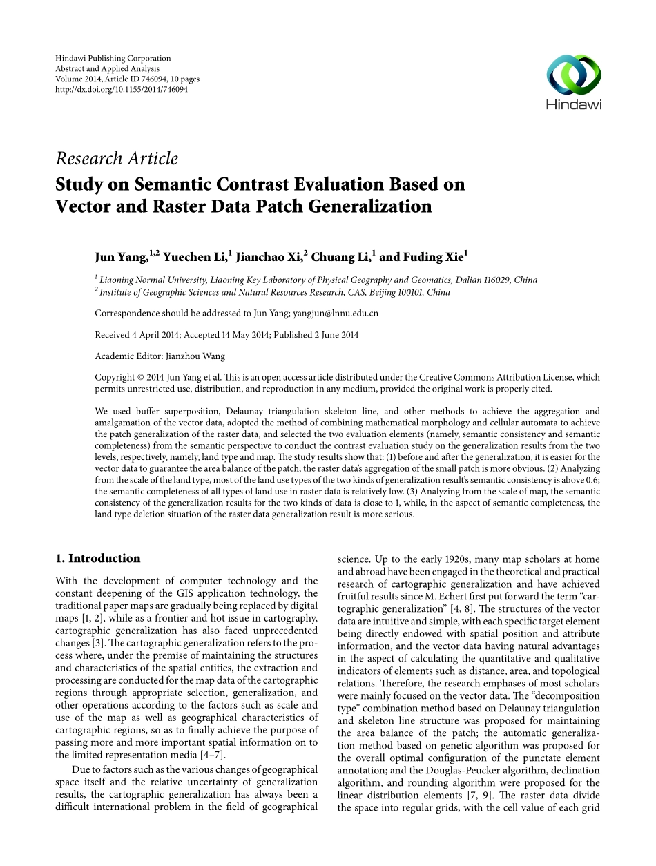
Weusedbuffersuperposition,Delaunaytriangulationskeletonline,andothermethodstoachievetheaggregationandamalgamationofthevectordata,adoptedthemethodofcombiningmathematicalmorphologyandcellularautomatatoachievethepatchgeneralizationoftherasterdata,andselectedthetwoevaluationelements(namely,semanticconsistencyandsemanticcompleteness)fromthesemanticperspectivetoconductthecontrastevaluationstudyonthegeneralizationresultsfromthetwolevels,respectively,namely,landtypeandmap.Thestudyresultsshowthat:(1)beforeandafterthegeneralization,itiseasierforthevectordatatoguaranteetheareabalanceofthepatch;therasterdata’saggregationofthesmallpatchismoreobvious.(2)Analyzingfromthescaleofthelandtype,mostofthelandusetypesofthetwokindsofgeneralizationresult’ssemanticconsistencyisabove0.6;thesemanticcompletenessofalltypesoflanduseinrasterdataisrelativelylow.(3)Analyzingfromthescaleofmap,thesemanticconsistencyofthegeneralizationresultsforthetwokindsofdataiscloseto1,while,intheaspectofsemanticcompleteness,thelandtypedeletionsituationoftherasterdatageneralizationresultismoreserious.1.IntroductionWiththedevelopmentofcomputertechnologyandtheconstantdeepeningoftheGISapplicationtechnology,thetraditionalpapermapsaregraduallybeingreplacedbydigitalmaps[1,2],whileasafrontierandhotissueincartography,cartographicgeneralizationhasalsofacedunprecedentedchanges[3].Thecartographicgeneralizationreferstothepro-cesswhere,underthepremiseofmaintainingthestructuresandcharacteristicsofthespatialentities,theextractionandprocessingareconductedforthemapdataofthecartographicregionsthroughappropriateselection,generalization,andotheroperationsaccordingtothefactorssuchasscaleanduseofthemapaswellasgeographicalcharacteristicsofcartographicregions,soastofinallyachievethepurposeofpassingmoreandmoreimportantspatialinformationontothelimitedrepresentationmedia[4–7].Duetofactorssuchasthevariouschangesofgeographicalspaceitselfandtherelativeuncertaintyofgeneralizationresults,thecartographicgeneralizationhasalwaysbeenadifficultinternationalprobleminthefieldofgeographicalscience.Uptotheearly1920s,manymapscholarsathomeandabroadhavebeenengagedinthetheoreticalandpracticalresearchofcartographicgeneralizationandhaveachievedfruitfulresultssinceM.Echertfirstputforwardtheterm“car-tographicgeneralization”[4,8].Thestructuresofthevectordataareintuitiveandsimple,witheachspecifictargetelementbeingdirectlyendowedwithspatialpositionandattributeinformation,andthevectordatahavingnaturaladvantagesintheaspectofcalculatingthequantitativeandqualitativeindicatorsofelementssuchasdistance,area,andtopologicalrelations.Therefore,theresearchemphasesofmostscholarsweremainlyfocusedonthevectordat...