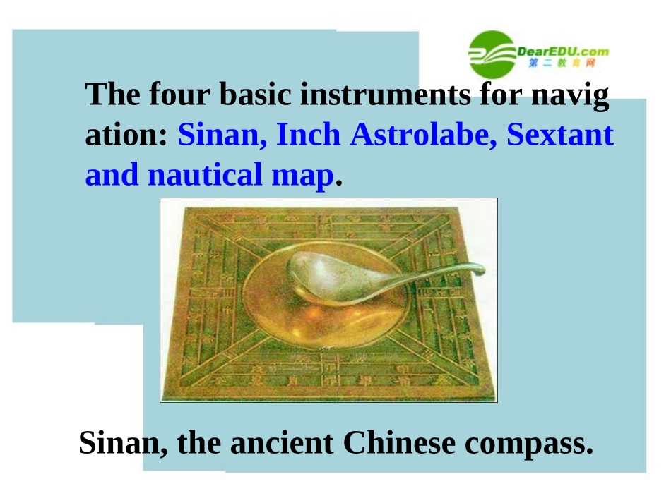
ReadingThefourbasicinstrumentsfornavigation:Sinan,InchAstrolabe,Sextantandnauticalmap.Sinan,theancientChinesecompass.ItwasinventedbyZhangHengintheHandynasty.Itismadeupofabronzefoundation(青铜地盘)andmagneticspoon(磁勺)whichismadeofnaturalmagnet,positionedrightinthecentralofthefoundation.ItwasinventedbyZhangHengintheHandynasty.Itismadeupofabronzefoundation(青铜地盘)andmagneticspoon(磁勺)whichismadeofnaturalmagnet,positionedrightinthecentralofthefoundation.Thehandleofthespoonpointstothesouth,whiletheothersidepointstothenorth.WhentheSinanisinthestill,thehandleofthespoonpointstothesouthbecauseofinfluenceoftheterrestrialmagnetism(地磁).Ithas17starslistedaswellasamapoftheskyoverhead(for37degrees)andtheecliptic(黄道).ThetimeofdayornightisontheoutsideedgewithnoonatthetopoftheAstrolabeandmidnightatthebottom.Itcomeswithacarryingchain,apouch,andabookonitsuse.Thereversesidehasasightformeasuringtheelevationsoftheheavenlybodies.astrolabeastrolabesextantThesextantisanavigationalinstrumentformeasuringtheanglebetweenthehorizonandsomeobjectinthesky.Firstasailorlooksatthehorizonthroughaneyepiece.Atthesametimehecanseelightfromthesunorastarreflectedoffasmallmirrorontopoftheinstrument,ontoasecondmirrorandintotheeyepiece.Thesextantisanavigationalinstrumentformeasuringtheanglebetweenthehorizonandsomeobjectinthesky.Firstasailorlooksatthehorizonthroughaneyepiece.Atthesametimehecanseelightfromthesunorastarreflectedoffasmallmirrorontopoftheinstrument,ontoasecondmirrorandintotheeyepiece.Thenavigatorcanthenseetwoimages,thehorizonandthesunsidebyside.Hecanthenmeasuretheanglebetweenthemonascaleatthebottomoftheinstrument.Thescalegoesfrom0to120degrees.Anearlierinstrument,calledaquadrant,measuredinangleinthesamewaybutitcouldonlymeasureanglesfrom0to90degrees.Thenavigatorcanthenseetwoimages,thehorizonandthesunsidebyside.Hecanthenmeasuretheanglebetweenthemonascaleatthebottomoftheinstrument.Thescalegoesfrom0to120degrees.Anearlierinstrument,calledaquadrant,measuredinangleinthesamewaybutitcouldonlymeasureanglesfrom0to90degrees.nauticalchartnauticalchartNauticalchartsaremapsofthedepthoftheseaandthecurrentsoftheoceans.Theyprovidemodernsailorswithroutesthroughtheseas,ratherlikeroadsthroughthecountryside.Theinformationbegantobecollectedinthenineteenthcenturyandhascontinuedtobeupdatedeversince.ThesechartswerenotavailabletoCaptainBlighorZhengHe.Nauticalchartsaremapsofthedepthoftheseaandthecurrentsoftheoceans.Theyprovidemodernsailorswithroutesthroughtheseas,ratherlikeroadsthroughthecountryside.Theinformationbegantobecollectedinthenineteenthcenturyandhascontinuedtobeupdatedeversince.ThesechartswerenotavailabletoCaptainBlighorZhengHe.Discuss1.Howdoyouthinkseamenfoundtheirwaybeforemodernaccuratemethodsofnavigationwereinvented?1.Howdoyouthinkseamenfoundtheirwaybeforemodernaccuratemethodsofnavigationwereinvented?Keptclosetotheshore,usednaturesuchasthesun,wind,birds,tide,etc,tohelpthem,andusedsomeoftheinstrumentsincludingacompass,astrolabe,etc.Keptclosetotheshore,usednaturesuchasthesun,wind,birds,tide,etc,tohelpthem,andusedsomeoftheinstrumentsincludingacompass,astrolabe,etc.2.Whichdoyouthinkwaseasiertoworkout:latitudeorlongitude?Latitude,becauseitwasusedtomeasurehowfaryouhadtraveledfromlandonastraightline.Itwasdiscoveredalongtimebeforelongitude.3.Canyouidentifytheseearlynavigationalinstrumentsseamenusedandexplainhowtheyareu...