ChapterOneChapterOne•GeographyGeographyLearningFocus–NationalFlagandnationalanthem–NamesoftheU.K.–Composition.–Topography.–ClimateFeatures.–Riversandlakes.–Maincities.
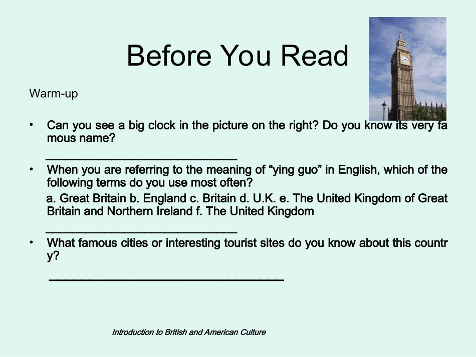
IntroductiontoBritishandAmericanCultureBeforeYouReadWarm-up•Canyouseeabigclockinthepictureontheright?Doyouknowitsveryfamousname?_____________________________•Whenyouarereferringtothemeaningof“yingguo”inEnglish,whichofthefollowingtermsdoyouusemostoften?a.GreatBritainb.Englandc.Britaind.U.K.e.TheUnitedKingdomofGreatBritainandNorthernIrelandf.TheUnitedKingdom_____________________________•Whatfamouscitiesorinterestingtouristsitesdoyouknowaboutthiscountry?_____________________________FullName:TheUnitedKingdomofGreatBritainandNorthernIrelandShortnames:TheUnitedKingdomU.K.TheGreatBritainBritainEnglandTheBritishIslesTheBritishlionQuestion:whatarethedifferencesamongtheseshortnames?TheBritishIsles•Explanationoftheterm:TheBritishIslesisthenameofsomeislandsinWesternEurope,separatedfromtheEuropeancontinentbytheNorthSea,theStraitofDoverandtheEnglishChannel.Amongtheislands,GreatBritainandIrelandarethetwomainones.ThecountryoftheU.K.mainlyconsistsofthesetwoislands.•Twomainislands:GreatBritainandIrelandThreeterms•BritishIsles•Britain•GreatBritainTwolargeislandsseveralsmallonesTheUnitedKingdomofGreatBritainandNorthernIreland.England,WalesScotlandDifferentNamesforBritainanditsParts1.Officialname:theUnitedKingdomofGreatBritainandNorthernIreland.2.TheDefinitionofTheUK.,GreatBritainandEngland.England,Scotland,WalesNorthernIreland.GreatBritainIrelandhundredsofsmallones.TheUKGreatBritain3.TheBritishIsles:Geographicallocation(1)•TheUKisan_______country.•TheUKislocatedinthe___________Europe.TheUKislandnorthwesternMapoftheUKReadthemaptofind:AtlanticOceanNorthSeaIrishSeaTheEnglishChannel(TheChannelTunnel)TheRepublicofIrelandTheConstituentPartsoftheU.K.1.England2.Scotland3.Wales4.NorthernIreland5.HundredsofsmallislandsIntroductiontoBritishandAmericanCulture英吉利-多佛尔海峡由英吉利海峡和多佛尔海峡组成,位于欧洲大陆和大不列颠岛之间,是沟通北海和大西洋的重要海上通道,是国际航运量最大的水道。以朴茨茅斯港为界,西南是英吉利海峡,东北为多佛尔海峡。海峡东窄西宽呈喇叭形.TheEnglishChannelandTheStraitofDoverTheEnglishChannel(英吉利海峡)TheStraitofDover(多佛尔海峡)1)TheBritishIsles–ageographictermwhichincludestwolargeislands,and,and5,000smallislands.2)GreatBritain:comprisesonlyEngland,and_______.3)Irelandisland:includesNorthernIrelandandsouthernIreland.NorthernIrelandisapartof,whilesouthernIrelandbecameanindependentcountry–.4)TheUK:ismadeupofand.ismadeupof,,_______and________Ex1:Fillintheblanksbelow.GreatBritainIrelandislandScotlandWalesTheUKRepublicofIrelandGreatBritainNorthernIrelandEnglandScotlandWalesNorthernIrelandEx2:Whatisthereferenceofeachpicture?BritishIsles,theUK,GreatBritain,Scotland,England,orWales?123456TheUKScotlandGreatBritainEnglandBritishIslesWalesTheFourRegionsoftheU.K.1.England(I)GeneralViewofEnglandDominanceinpopulation,cultureandeconomySize:130,281squarekilometers(53.7%)Populationdensity:401persquarekilo全球人口密度最大的国家和地区前5位分别为孟加拉国(People'sRepublicofBangladesh)、中国台湾、韩国、黎巴嫩(TheRepublicofLebanon)和卢旺达(TheRepublicofRwanda)。中国虽然是人口最多的国家,但由于幅员广阔,平均每平方公里仅有140人。(2)England’sreferringtoU.K.------rightornot?Englandisthelargestand...